- Home Home
-
Residents
Residents
- Waste & recycling Bins, clean-ups and disposing of tricky household items
- Parking Permits, car parks, maps and safety
- Your trees, plants & garden Tree pruning, native gardens and Living Connections
- Neighbourhood issues Report and resolve common issues
- Pets Dog and cat ownership, lost animals and off-leash parks
- Precinct committees Your local connection to Council
- Waverley LGA Maps Maps of the environment, planning zones and more
- Payments Pay for rates, certificates, permits and licences
-
Community
Community
- Children, youth & family services Early education, day care, support & resources
- Awards & grants Local Hero Awards, Garden Awards, Small Grants
- Get involved in your community Volunteering, creating connections, gardening
- Over 60s Services, activities, Mill Hill 60+ program
- Housing & homelessness Affordable housing, programs & support services
- Cultural diversity & inclusion Multiculturalism, language help, citizenship
- Aboriginal & Torres Strait Islander people Commitment to Reconciliation, plans & policies
- Disability inclusion Support services, access & inclusion projects
-
Business
Business
- Resources for Business Events, grants and support
- Innovation Roadmap 2025 to support business
- Tourism Home to Australia's most famous beach.
- Sponsorship Support local events
- Procurement Submitting tenders & expressions of interest to Council
- Commercial waste & recycling services Tailored waste services for business
- Mobile vending Waverley has limited mobile vending licenses
- Hello Bondi Council’s website to help visitors enjoy their stay
-
Recreation
Recreation
- Events Browse performances, exhibits and experiences
- Places of interest Historic buildings, markets, dining and Bondi Pavilion
- School Holiday Programs Fun-filled activities, workshops and events.
- Beaches & coast Beach information, safety, pool cleaning schedules
- Parks & reserves Location, public facilities and accessibility
- Arts & culture Artistic vision, creative programs, spaces and awards
- Venue & sport facilities hire Book indoor venues and sport facilities in Waverley
- Use of public spaces Events, commercial activations, filming etc
-
Environment
Environment
- Council leadership on environmental action Research, strategies and Council programs
- Climate resilience and reducing emissions Switch to electric, go solar and grants for apartments
- Water and the coast Keep beaches clean, save water and enjoy the sea
- Towards zero waste Reduce waste at home and at work
- Public tree management & urban greening Street Tree Masterplan and planting zones
- Native vegetation and animal habitat Join Bushcare and enjoy Waverley’s natural spaces
- Transport Council policy, bike and car share, electric vehicles
- Second Nature Council’s environmental news and events hub
-
Planning & Development
Planning & Development
- Development Applications The DA process, key documents & community consultation
- DA Tracking Tool Search a Development Application by number or date
- Application forms & certificates incl Planning, Rating, Construction and Occupation
- Waverley Local Planning Panel (WLPP) DA determination panel
- Compliance and regulations incl fire safety, food, pools and pollution
- Heritage incl Heritage Conservation Areas and fact sheets
- Urban planning and design Making Waverley a great place to live and work
- Major projects Council-delivered buildings, streets and parks
-
Council
Council
- Organisation structure Four directorates serve the community
- Mayor & councillors Your Mayor, Councillors, wards and contact details
- Council & committee meetings Dates, agendas and minutes of meetings of Council
- Advisory committees Advisory Committees of Council
- Policies, plans, strategies and reports Council's vision and delivery
- Jobs Current vacancies and working at Waverley
- Access to information Gaining access to publicly available information
- Payments Pay for rates, certificates, permits and licences
- Waste & recycling
- Parking
- Your trees, plants & garden
- Neighbourhood issues
- Pets
- Precinct committees
- Waverley LGA Maps
- Payments
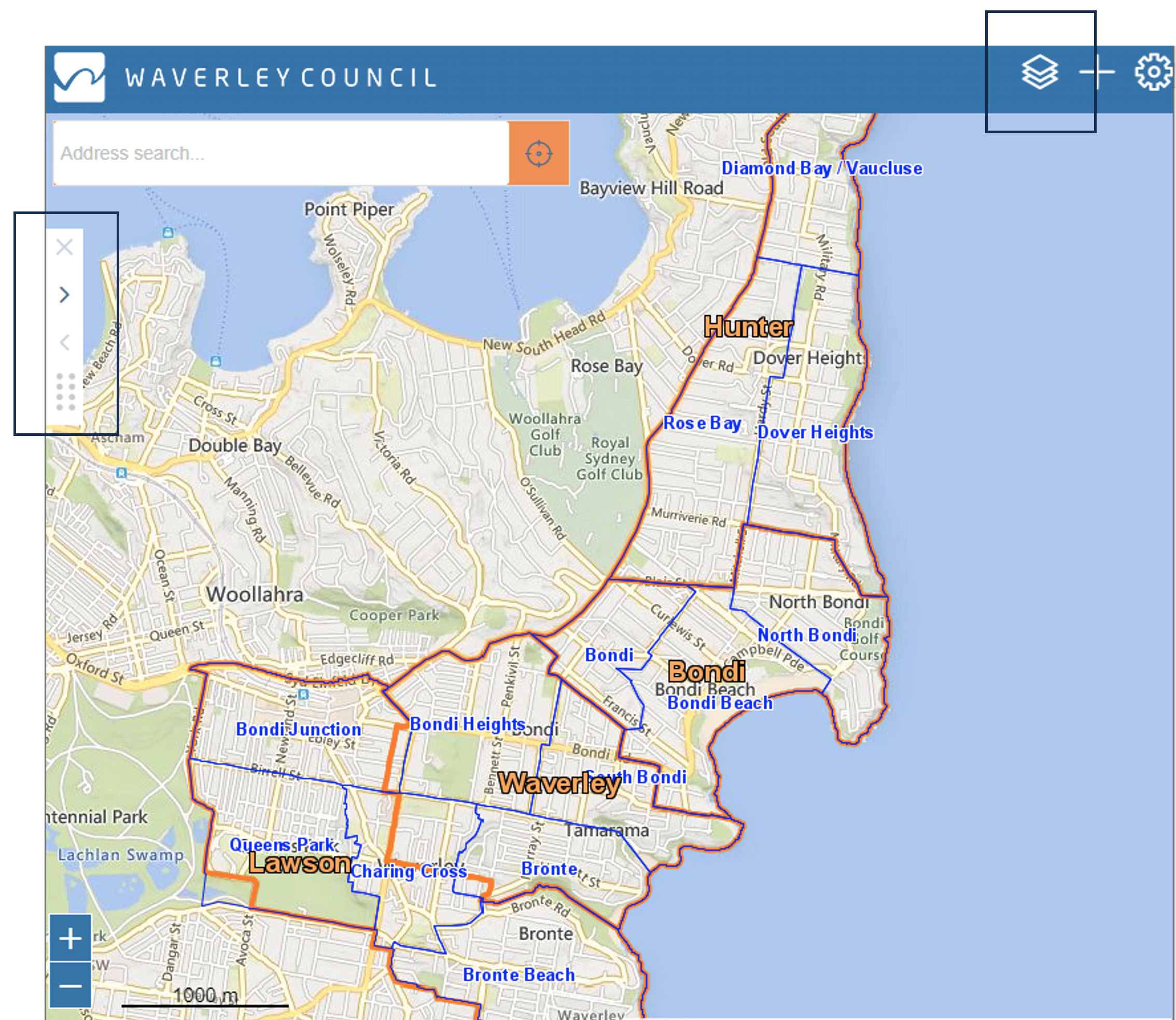
Waverley LGA Maps
‘Discovery Waverley’ online mapping service provides a snapshot of amenities, services, and planning controls in our local government area (LGA).
Maps:
- Accessibility Map - this map can help people with mobility requirements and people who use mobility aids, such as wheelchairs, to better navigate the neighbourhood.
- Aerial Map - view current and historical aerial imagery of the local area as far back as 1943.
- Capital Works Map - view locations of Council’s current capital works projects, as well as timing of works and contact information.
- Council Wards & Precincts Map – Residents can connect with their local Precinct in order to attend local meetings.
- Planning Map - view local planning controls such as zoning, heritage, flood, etc relating to your property from Council’s Local Environmental Plan (LEP) and Development Control Plan (DCP). Note this information is a guide only.
- Public Map - local services including community centres, venues for hire, public WIFI, childcare centres, schools, toilets, buildings, parking and dog parks.
- Street and Park Trees Map - view the species of any public tree in the LGA and whether it is indigenous or exotic.
- Transport & Parking – view parking areas, local bus stops, popular walking path and cycleways.
Using Discovery Waverley
The mapping service uses layers which you can select by using the button on the top right.
Once you have click on a location on the map, use the toggle button on the left to display information relevant to address you selected.
Something missing or not look right? Let us know on gis@waverley.nsw.gov.au.
Disclaimer & Acknowledgement
The information included in Discovery Waverley has been compiled from various sources and is subject to modifications and continual updating over time. Council updates the map content regularly, but cannot guarantee its accuracy. The information contained should be considered as a guide only and is not suitable for professional applications such as in Development Applications.
Discovery Waverley is made possible thanks to Aerial Imagery Nearmap and NSW Spatial Service. Aerial Imagery used is supplied for Council’s purposes by, and is subject to agreement with, AAM Hatch and Sinclair Knight Merz Pty Ltd.