Street Tree Masterplan
The Waverley Local Government Area (LGA) is only 9.35 square km but is home to nearly 70,000 people. The 2021 census found 83.3% of dwellings in the LGA were classed as medium or high density compared to 46% in Great Sydney, making the preservation and enhancement of the limited green space critical to liveability.
The Waverley Tree Management Policy and Tree Management Guidelines are key documents which outline Council’s protection of trees in both private and public land.
Street trees are often the dominant landscape factor in the community and one of the most effective ways of improving the image and character of our streets and suburbs. They provide environmental and aesthetic benefits, can have cultural significance by reflecting the LGA’s history and provide functional outcomes including screening and shade.
With over 10,000 street trees in the LGA, planting new trees requires a co-ordinated approach and the masterplan provides:
- A sound framework for the selection of trees
- Better tools for the planning and budgeting of future tree planting projects
- Improved techniques for tree planting and protection
- A broader choice and selection of trees through the trialling of new species and cultivars
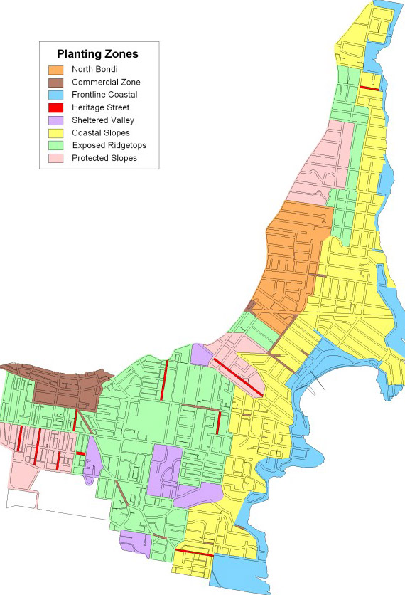
The map below illustrates the various Planting Zones, each having a unique streetscape character, priority species and considerations. You can also use Council's Street and Park Trees map to view the species of any public tree in the LGA and whether it is indigenous or exotic. The zone information can also be useful for private gardeners when considering the best trees for their home.
The eights zones are:
- Frontline Coastal: the areas directly exposed to strong salt-laden winds with little or no protection.
- Coastal Slopes and Basin: within one kilometre of the coast but directly and indirectly affected by coastal winds.
- Exposed Ridgetops / Shallow Soils Over Sandstone: the streets on the high ridge-line exposed to coastal winds around Dover Heights, Vaucluse and Tamarama and the westerly and southerly winds around Bondi Junction and Charing Cross. Also the areas of shallow soil overlying sandstone. These areas once supported low growing heath communities.
- Heritage Streets: heritage listed streets recognised for the significance of their trees and their contribution to the immediate area.
- Commercial: the areas around the main commercial precincts and local village precincts.
- North Bondi / Rose Bay: the area that once supported large stands of Eastern Suburbs Banksia Scrub and is known to have deep sandy soils.
- Protected Slopes: the more protected slopes below the ridge-lines of Rose Bay and Queens Park. Usually sheltered from prevailing winds.
- Sheltered Valleys: the small gullies in Queens Park and behind Bronte Beach and Tamarama.